Water Cycle Series: From rainfall to drinking water systems, this series will explore how the natural and built environment impact the water cycle. This entry is the first in a series of blogs to highlight the interconnectedness of water systems. Please follow along as we explore watersheds, drinking and wastewater systems, and the role we all play in the quality of our water and the health of our communities!
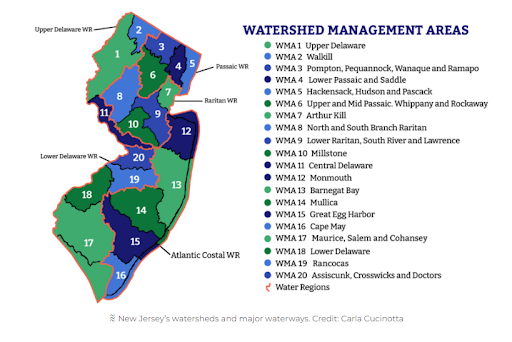
Right now, you are in a watershed. A watershed is an area of land that “sheds” rainfall and snowmelt to rivers, streams, and creeks, and eventually flows into a larger body of water like bays, estuaries, reservoirs, and oceans. Think of watersheds like a bathtub; any water entering the tub eventually goes down the drain, just like water falling in a watershed will eventually drain to a larger body of water. To manage the health of our critical water resources, New Jersey is organized by 5 water regions–Atlantic Coastal, Lower Delaware, Northeast, Northwest and Raritan–and twenty (20) Watershed Management Areas (WMAs) (See Image 1: Watershed Management Areas of NJ, Source: NJ Spotlight). From small creeks running behind our homes, to scenic rivers that serve as major recreation destinations and critical habitat for wildlife, these delineated areas demonstrate the diversity and unique nature of water features across the state. These regions and WMAs also help water resource managers and policy makers make informed decisions about water quality, localized flooding, and overall watershed health.
Regardless of where we live, we all play a role in watershed health. Where the water flows to, determines your watershed “address”. Topography, or the slope of the land, and permeability, how water is absorbed, are key attributes of a watershed. Human activities can shape watersheds, for better or, more commonly for worse. For example, urbanization leads to increased impervious cover, thus more runoff and less natural absorption into soils and groundwater. This leads to more localized flooding and more untreated pollutants running off the land into our waterways. These issues are particularly acute in New Jersey, where our density, urbanization, and industrial legacy have compounded to provide rainfall with scarce places to flow on its way from streets and sewers to our rivers, bays, and ocean. Without proper land management through a watershed lens, we are disconnecting natural systems and experiencing these negative impacts.
What we do upstream, impacts communities and its natural features downstream. Large swaths of impervious surfaces–roadways, buildings, and parking lots–upstream, force stormwater running off or “shedding” downstream. These upstream land uses are tied to impacts like water quality impairments and localized flooding downstream. Protecting and expanding natural features like wetlands, forested areas, and riparian buffers, can enhance the functionality of watersheds. “Disconnecting”, or removing impervious cover, naturalizing our gray infrastructure, and installing new green infrastructure —such as bioswales, rain barrels and gardens— can also restore natural functionality of watersheds in our more urbanized areas. Effective watershed management can minimize flooding and improve water quality, thus improving and protecting critical water resources that we rely on for drinking, recreating, and for economic growth.
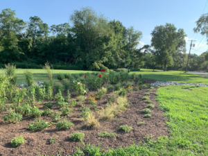
Image 2: Rain Garden in Manville. Rain gardens are a great example of green infrastructure that can enhance the functionality of watersheds. (Source: NJF)
How does New Jersey currently manage watershed health? While we have 20 Watershed Management Areas (WMAs) in New Jersey, stormwater management is mainly conducted at the municipal level. New Jersey is a “home rule” state therefore much of our planning and implementation of solutions occurs on the municipal level. 60% of our water quality impairments can be attributed to nonpoint source pollution. Meaning, we cannot tie more than half of our water pollution to a specific source. So not only does flooding not pay mind to municipal boundaries, the identification of pollutant sources is difficult and determining effective solutions cumbersome. New Jersey’s Department of Environmental Protection (NJDEP) is working to amend this issue. In 2020, NJDEP formed the Watershed and Land Management Program, reflecting a paradigm shift toward linking land use regulations and water resource protection. A prime example of this shift in policy is the newly revised Tier A MS4 permit that requires municipalities to complete Watershed Improvement Plans (WIPs) over the next 5 years. The WIP process and its implementation will begin to address nonpoint source pollution throughout New Jersey.
Much like watershed boundaries, flooding and water pollutants continue to pay no mind to municipal lines. Therefore, regional solutions should be explored. An example of watershed-based regional planning is South Carolina’s Office of Resilience development of resilience plans for each watershed in the state to develop placed-based solutions to flooding. New Jersey has a history of implementing regional solutions to address the unique needs of a given geography. One key example is the Pinelands Comprehensive Management Plan (CMP) which established nine land use management areas with goals and development intensities and permitted uses for each area. Since its adoption in 1981, The CMP has successfully preserved valuable water resources, wildlife, historic resources, agricultural lands, and other critical features of the Pinelands National Reserve. How to move forward with regional planning for water quality and flooding in New Jersey has been explored in the past, however based on best practices across the country and success of previous regional planning efforts like the Pinelands CMP, an incentive or directive from the state level may be the best approach. In the meantime, NJDEP has made Stormwater Assistance grants available so municipalities can begin or refine their stormwater mapping and start planning watershed improvement projects to improve water quality and reduce flooding. With stormwater infrastructure mapped over the next few years, municipalities should be well equipped to begin to identify projects that impact not just their community, but the greater watershed in which they reside.
This blog was written by, Lindsey Sigmund, PP, AICP, Mainstreaming Green Infrastructure Program Manager at New Jersey Future.
Visit the New Jersey Municipal Green Infrastructure Toolkit here: https://gitoolkit.njfuture.org/.